Written by Victoria Gresham | January 7, 2022
While the prehistory of Indiana spans from ca. 10,000 B.C to approximately 1650 A.D. at a time when the Europeans began to keep record of its historical accounts, Porter County was mostly unchartered land inhabited by various native American Indian tribes. While Joseph Baily is accredited with erecting the first homestead in Porter County, J.P. Ballard broke ground to erect the first house in the new town of Portersville in 1833, which would become known as Valparaiso in 1837. Ballard’s kitchen would become the first meeting place of the newly elected Porter County Commissioners. The Commissioners were then tasked with selecting the county seat, which became known as Portersville in 1836.
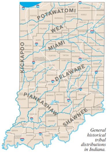
The native people of the Iroquois Wars (1641-1701) were known as the Potawatomi and Miami tribes that next occupied the lands of Porter County. It would be over 125 years later before the towns of Chiqua and Tassinong would appear on maps and in records. Chiqua is a mile east of Valparaiso on State Route 2 on the old Sauk Trail and Tassinong is on State Road 49 about 5 miles south at Baums’ Bridge Road. Porter County spans nearly 522 miles of terrain with its highest peak at an elevation of 870 feet located in Jackson Township and its lowest point at 585 feet along Lake Michigan’s shoreline.
(Image Source: Early Peoples of Indiana, Indiana Department of Natural Resources Division of Historic Preservation and Archaeology (DHPA) James R. Jones III, Ph.D. and Amy L. Johnson, Page 25, Revised 2016)
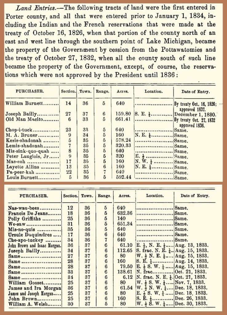
Land in this region became the property of the Government due to the cession from the Pottawatomie and the treaty of October 27, 1832 except for the reservations until 1836, which were approved by President Andrew Jackson. William Burnett purchased 640 acres in section 14, township 36 by virtue of the treaty on October 16, 1826, to which his purchase was approved in 1837. Joseph Bailly purchased 159.80 acres in section 27, township 37 and staked his claim to the land on December 1, 1830. The federal government negotiated treaties between the Native-Americans in Indiana beginning with the Treaty of Greenville in 1795 and ceasing with the Treaty of Chicago in 1833. During this time, many sections of land within Porter County were purchased by settlers and Native-Americans including William Burnett, Joseph Bailly, We-saw, William Gosset, James and Ira Morgan, and James and Joseph Morgan.
(Image Source: Counties of Porter and Lake Indiana Historical and Biographical Chicago F.A. Battey and Co., Publishers 1882 (Pages 34-35)
In 1832, the federal government purchased land which unfortunately became undesirable. Congress had also donated swamp lands located in Porter County to the State of Indiana but they yielded no revenue. Thomas Campbell scouted the Sauk Trail and became one of the first settlers of the new area. In a turn of events, the trail would later have a significant contribution to the nation’s first development of the transcontinental highway system known as U.S. Highway 30. It is one of the first federal roads, which follows the Oregan Trail in the West. Today, it is the third longest U.S. highway ranked after U.S. Highway 20 and lastly, U.S. Highway 6 as the longest highway in our nation.
The old Indian Sauk Trail is a portion of the 3,073 miles of east-west highway commissioned in 1926 that runs through 12 states including Oregon, Idaho, Wyoming, Nebraska, Iowa, Illinois, Indiana, West Virginia, Pennsylvania, and New Jersey.
(Image Source: roadandrailpictures.com 2005)
Portersville was a heavily wooded location abundant in oak, ash, maple, birch, and pine trees. Game roamed freely making it an ideal place for food source and sport. Benjamin Harrison, before becoming President, regularly hunted and fished this part of the country. The Portersville Land Company developed the town’s public square from donated land. The company platted the lots, which sold out in three years at $100 each.
Twenty years after Indiana became a state in 1816; Governor Noble approved an act “to organize the County of Porter, and for other purposes” on January 28, 1836. The northwest territory was first formed into La Porte County in 1835, complete with an election of Commissioners held on February 23, 1836. Governor Noble then appointed Benjamin Saylor as Sheriff and gave him the power to organize the county. Sheriff Saylor called for an election of public officials, which included Judges of the Probate Court, three County Commissioners, Recorder and Clerk. The election was held on February 23, 1836 at designated homesteads of the territory’s first settlers.
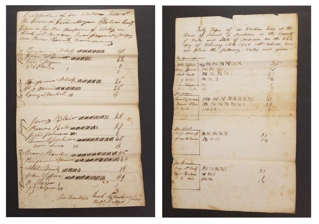
Image Source: Porter County Clerk’s Archives, Porter County, Indiana. Photo Credit: Victoria Gresham, January 26, 2022
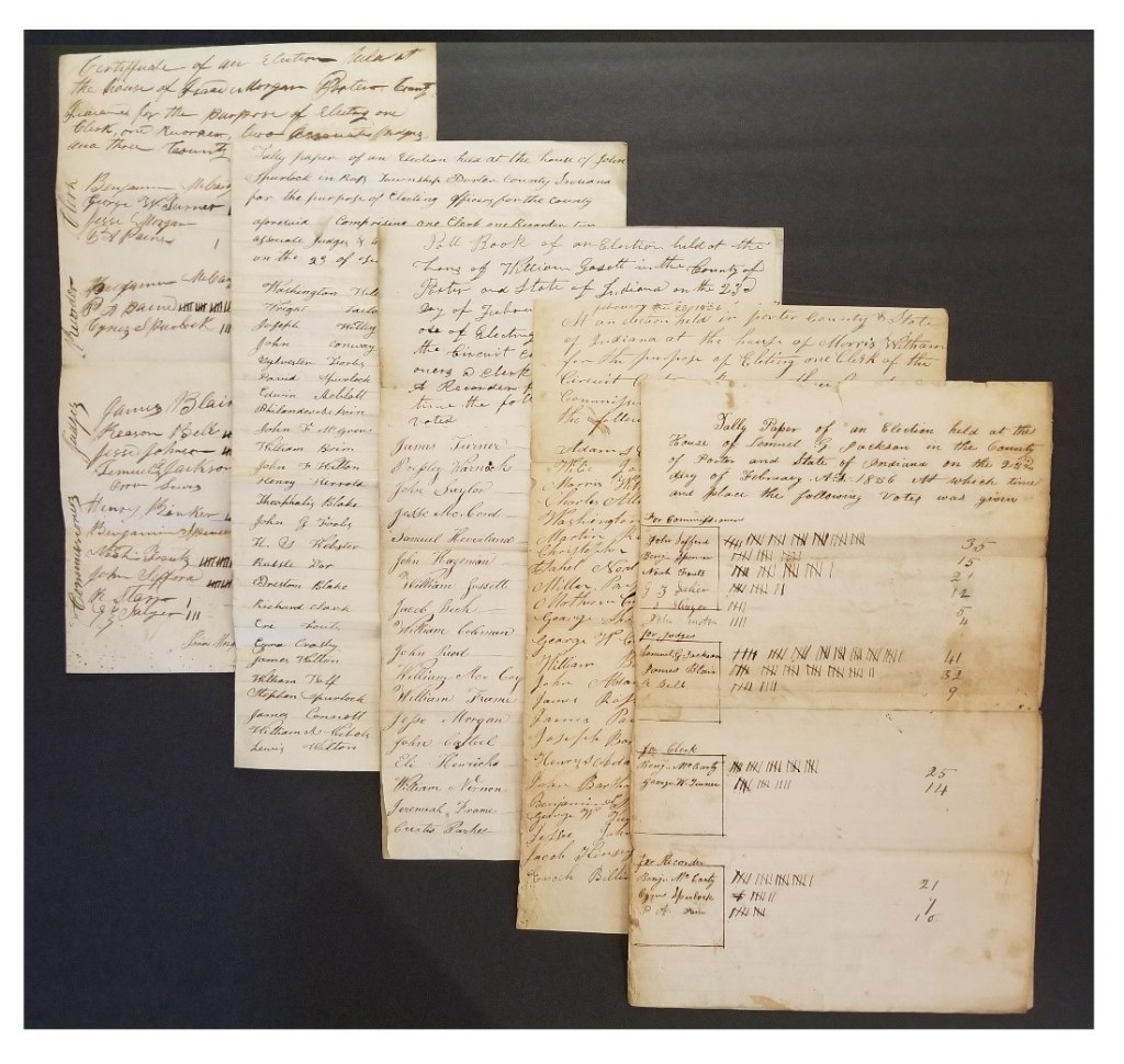
Image Source: Porter County Clerk’s Archives, Porter County, Indiana. Photo Credit: Victoria Gresham, January 26, 2022
(References: Porter County Clerk’s Office, Archive Division; Counties of Porter and Lake Indiana Historical and Biographical: Chicago F.A. Battey and Co., Publishers 1882 (Pages 34-35); History of Porter County, Indiana, 1912, The Lewis Publishing Company; Environmental Setting of the Upper Illinois River Basin and Implications for Water Quality Water-Resources Investigations Report 98–4268; Tanner, Helen Hornbeck, Atlas of Great Lakes Indian History; University of Oklahoma Press, Norman, Oklahoma (1987) Map 5; Hough, Jack L., Geology of the Great Lakes; University of Illinois Press, Urbana (1958) p. 276; CoHP.org Trip Report for Porter, IN by Mike Schwartz Oct. 25, 2000; Early Peoples of Indiana, Indiana Department of Natural Resources, Revised 2016; Encyclopedia of Prehistory: Volume 6: North America, Page 399, Peter N. Peregrine, Melvin Ember, 2012; Encyclopedia of Chicago, 2005 Chicago Historical Society; The Lewis Publishing Company. 1912. History of Porter County, Indiana: A Narrative Account of its Historical Progress, its People and its Principal Interests. Volume I. Chicago, Illinois: The Lewis Publishing Company, Page 357)
