Written by Victoria Vasquez | July 8, 2026

Echoes of the Land
In the early 1800s, the Potawatomi people controlled vast amounts of land across northern Indiana. Their territory spanned the southern shores of Lake Michigan, stretching south to the Wabash River. The Potawatomi lived heavily throughout the modern St. Joseph, Kankakee, and Elkhart River valleys, including what is known today as the City of Portage, Porter County, Indiana.
The Miami and Potawatomi Tribes inhabited the Northern Indiana region between the late 1600s to late 18th century. The Miami tribe was the principal indigenous tribe, but relocated due to the Iroquois expansion with the fur trade. After the Iroquois retreat, the Potawatomi became the dominant tribe along the southern shores of Lake Michigan, having over 30 documented settlements by the late 18th century. By 1820, they occupied most of northern Indiana and Illinois settling along Lake Michigan.
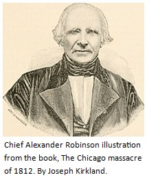
The cession of the territory of what is now known as Porter County, began in October, 1832. However, land cessions began as early as 1783 in the southern-parts of Indiana. The chief of the State was M. Alexandre Robinson, around 1829. He was also known as Che-che-pin-quay or “The Squinter.” His father was Scots-Irish and his mother was of Ottawa descent. He was elected at that time with almost absolute power over the Ojibwe (Chippewa), Ottawa and Potawatomi tribes, together known as the “Council of Three Fires.” Many treaties held between 1829-1833 were negotiated with his help and translations to the tribes.
As a young man Robinson was apprenticed to a fur trader further south in Michigan, by the name of Joseph Bailly, a name well-known today by most Porter County residents. Bailly later settled in the northern parts of Indiana, which is now known as Bailly’s Homestead in the town of Porter, Indiana. Today, it is nestled near U.S. Highway 20 and Mineral Springs Road, just inside the Indiana Dunes National Park. Bailly’s trading post was one of few stops along the stagecoach road between Detroit and Fort Dearborn (Chicago) for missionaries and travelers’ trips through the region. Chief Robinson and Chief Weesaw had a distinct connection with Porter County. Chief Robinson passed away on April 23, 1872 at 100 years old. Chief Weesaw died at approximately at the age of 51 years old in 1836.
WEESAW LAND DEED FOR TOWNSHIP 36
During the 17th and 18th centuries the Potawatomi migrated to northern Indiana and the Great Lakes from Canada and Wisconsin. In the mid-1800’s they ceded their land in Porter County due to intense westward expansion and the U.S. government’s forced removal policies. The land treaties dated between 1826-1838. These events occurred due to the federal Indian Removal Act of 1830. During the Treaty of Chicago in 1833, the Potawatomi gave up their remaining lands in Illinois, Wisconsin, Michigan and Indiana in exchange for reservation land west of the Mississippi. Land deeds were part of these transactions, such as the land deed held at the Porter County Clerk Archives that Chief Weesaw initiated between himself and Hyacinth Lasselle Sr. for “Township 36” in modern-day Porter County. This remarkable record connects the lives of two distinct figures in Indiana history. Their lives each played a significant role to how Porter County and the State of Indiana would forever be changed. On September 4, 1838, a band of 859 Potawatomi, including the remaining Potawatomies living in Porter County, were escorted from Twin Lakes, Indiana to a small reserve in present-day Kansas during a tragic march now known as the “Trail of Death.”
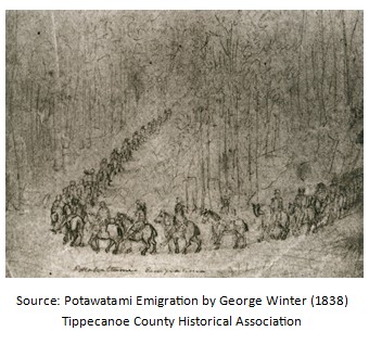
General John Tipton was authorized by Indiana Governor David Wallace to orchestrate the armed military removal. His official military log offers an account of the government’s tracking of the caravan’s daily movements. Voluntarily walking alongside the Potawatomi was Father Benjamin Marie Petit, a French-born Catholic priest, who had learned the Potawatomi language and baptized many tribal members into the Catholic faith. There was one exception negotiated by Chief Leopold Pokagon, a native leader, who negotiated for his band to stay in Michigan while other tribes were forced to leave. George Winter, an English-born artist who lived in Logansport, Indiana, in 1838 captured the 660-mile march through his sketching, which would become the only first-hand visual records of the removal.
This particular land deed for Township 36 may have been one of the final transactions made by Chief Weesaw, or any Potawatomi leader, since it occurred only one week prior to the mandated migrations. It may be one of the last connections the tribe had in relation to Porter County. The Potawatomi nation signed more treaties with the United States government than any other tribe making this land deed a pivotal moment in time.
BIOGRAPHY – ABOUT CHIEF WEESAW
Weesaw also known as Louizon or Motay, was a Potawatomi war chief and son of Anaquiba. Chief Weesaw lived in the early 1800s. His band’s village was located along the St. Joseph River, just south of present-day Niles, Michigan, and near the Indiana border. He signed several treaties that gradually gave up tribal lands to the United States government. He was a signer of the 1821 Treaty of Chicago that ceded to the United States most of the Potawatami holdings in Michigan, excluding a small portion of Berrien County and a small tract to Niles, Michigan. Chief Weesaw was a prominent subordinate war chief of the St. Joseph River Potawatomi band under the authority of Head Chief Topinabee.
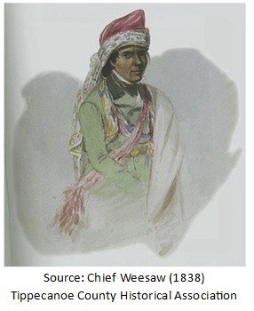
Weesaw signed a total of five major treaties between 1821 and 1836 between the Potawatomi nation and the United States government. Credits to his name include, Treaty of Carey Mission (1828); Treaty of Tippecanoe River (1832); Treaty of Chicago (1833); and Treaty of Chippewaynaug (1836). His name appears in those treaties with spelling variants such as Wesaw, We-is-saw, We-wis-sah, and Wisaw, including the alias Louison or Louizon, given to him as an alternate name. In the Treaty of Tippecanoe, October 27, 1832, a half-section of land was reserved to him. In another treaty signed at Chippewaynaig on September 23, 1836, four sections of land were reserved for “the band of We-saw.”
Weesaw’s significance to Portage, Indiana stems from the historical Potawatomi trails, land cessions and the regional water portage that connected the St. Joseph River valley to the Grand Calumet and Kankakee River systems. The City of Portage bears its name from the vital overland paths used by the Miami and Potawatomi nations, including Weesaw’s tribal band, who frequently utilized the transit corridors to move with their canoes between the local waterways of the St. Joseph River, the Little Calumet River and Lake Michigan for regional trade and seasonal hunting.
The name “Weesaw” translates to “He, The Torch Bearer”. Today, the Weesaw Township in Michigan honors his name. Also, descendants and present-day tribal leaders with the surname Weesaw are prominent members of the Pokagon Band of Potawatomi Indians. Today, the tribe has more than 6,000 citizens and its members live as a sovereign, federally recognized nation across a ten-county homeland in southwestern Michigan and northern Indiana.
BIOGRAPHY – ABOUT HYACINTH LASSELLE SR.
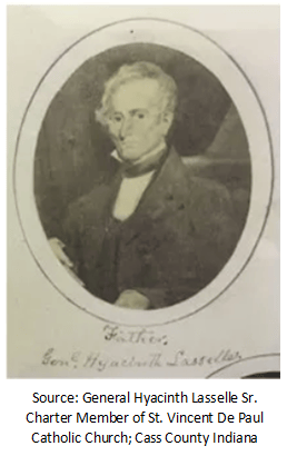
Hyacinth Lasselle, is best known as General Hyacinth Lasselle Sr., veteran, War of 1812. Hyacinth was an innkeeper and French trader from Vincennes, Indiana. He began his military career as a lieutenant and then major general in the Indiana militia. He was the father of four children, Charles, Stanislaus, Hyacinth Jr. and Jacques Magloire. In circa 1806, he purchased Polly Strong, who was born into slavery in the Northwest Territory. This would spark a movement that would rewrite history for a society of people in our state.
The 1816 Indiana Constitution prohibited slavery and involuntary servitude. In 1820, Polly’s case became a landmark case for those who pursued freedom. Strong had been a slave since birth and asserted her freedom from her then “master”, Hyacinth Lasselle. The language in the new Constitution replicated language that prohibited slavery and involuntary servitude in the 1787 Northwest Ordinance, a document that governed Indiana prior to statehood. Article Six of the Northwest Ordinance stated that “there shall be neither slavery nor involuntary servitude in the said territory.”
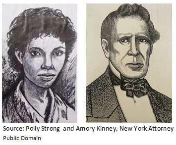
Strong and Amory Kinney, a young New York attorney and abolitionist who heard of Polly’s case, stepped in to pursue her freedom in the Knox County Circuit Court. However, the court ruled that Strong remain enslaved. Strong appealed to the Indiana Supreme Court in Corydon which ruled in her favor under the case, State v. Lasselle, July 22, 1820, with a decision from the court citing: “slavery can have no existence” in Indiana.
Lasselle was one of five proprietors of the land company which platted the village of Terre Haute, becoming one of its founders. Later, he settled in Logansport, Indiana. Hyacinth is buried in the “Old Cemetery” in Logansport, Cass County, Indiana. His connection with Porter County is sealed in the land deed transaction with Chief Weesaw, where he purchased Township 36 for the sum of $3,000.
TRANSCRIPTION OF WEESAW & LASSELLE LAND RECORD (1838)
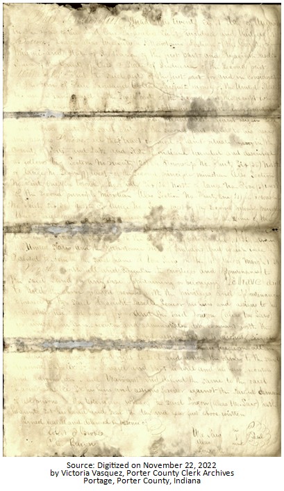
Chief Wee Saw alias Louizon to Hyacinth Laselle, Senior (August 28, 1838)
This Indenture made this twenty-eight day of August in the year of our Lord One Thousand Eight hundred and thirty-eight
Between Louizon alias Wee Saw a Potawatomi Indiana of the County of Miami and State of Indiana of the first part and Hyacinth LaSelle Senior of County of Cass & State of Indiana of the second part witnesseth that the said party of the first part for and in consideration of the sum of three thousand Dollars lawful money of the United States to him in hand paid by the said party of the second part the receipt where of here acknowledged by the second part of the first part hast given and granted [sic] and conveyed and by this presents doth grant bargain sell and convey unto the said party of the second part and to his heirs and assigns forever all that tract on parcel of land situated in the county of Porter and Lake and State of Indiana bounded and described as follows viz Section No Twenty (20) in Township No Thirty Six (36) North of Range No Seven (7) West of the Second principle meridian also Section No Thirty One (31) on Township No Thirty Six (36) North of Range No Five (5) West of the Second principle meridian Also Section No Thirty One (31) in Township No Thirty Six (36) North of Range No Seven West of the Second principle meridian which said three sections were reserved to said person by the name of Wee-Saw [sic] concluded on the Tippecanoe River in the State of Indiana on the 27th Day of October A.D. 1832 between the United States and the Potawatomi Tribe of Indiana and which were patented to him by the said name We Saw on the 4th day of March 1838
Together with all and singular the privileges and appurtenances to the said land in any use appertaining or belonging TO HAVE AND TO HOLD the above granted premises with the privileges and appurtenance aforesaid to the said Hyacinth LaSelle Senior his heirs and assigns to his and their use and behalf forever and the said Souizon (also We Saw) for himself his heirs executors and administrators doth covenant with the Hyacinth LaSelle for his heirs and assigns that he is lawfully seized [sic] promises that [sic] free from all [sic] that he has good rights to sell and convey the same to the said Hyacinth LaSalle Sr. as aforesaid and that he will and his heirs executors and administrators will warrant and defend the same to the said Hyacinth LaSalle Sr. his heirs and assigns forever against the lawful demand of all persons In testimony where of the said Louizon (alias Wee Saw) hath hereunto set his hand and seal the day and year first above written
Signed sealed and delivered in presence of ) Wee Saw his
Robert T. Groves ) Alias X {Seal}
Peter Baron ) Sourzou mark
Weesaw and Lasselle Sr. Land deed transcribed by Victoria Vasquez, Porter County Clerk Archives, July 1, 2026. Spelling of individual names may vary based on the actual inscription of the document.
The Township 36 land tract from the Weesaw and Lasselle transaction may be further recognized as land within the land of Section 14 of the land cessions map, which is more commonly known as the northern parts of County Road 600 North.
These sections span across the modern borders of Porter and Lake Counties situated within Northwest Indiana. Historically, before Lake County was fully organized in 1837, the land in Range 7 West was part of the original wider boundaries of Porter County.
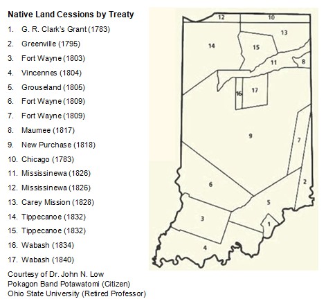
In modern-day definitions, the land deed would encompass the Lake County areas spanning from the city limits of Hobart, specifically containing Lake George and its surrounding historical neighborhoods to the borders of Lake Station and New Chicago, while stretching across the City of Portage to the rural areas of southwestern Jackson Township.
References: Porter County Clerk Archives, Portage, Indiana; NationalParkServices.gov; Indiana Dunes National Park Indiana; Indiana GENWEB, inportercounty.org; Wikipedia.com; Nottawaseppi Huron Band of the Potawatomi, https://nhbp-nsn.gov/history; The Citizen Potawatomi Nation Cultural Heritage Center; The Potawatomi Tribe-Legends of America; JStor.org- Indian Names in Michigan (c) 1986 University of Michigan Press; John N. Low, JD, Ph.D. (retired) Pokagon Band Potawatomi, Ohio State University; Findagrave.com: Memorial ID 9281505-hyacinth-lasselle; Indiana Historical Society: Lasselle Collection (1713-1809); Knox County Genealogy Library; Terre Haute Tribune Star (April 12, 2014); Indiana Supreme Court Case (1820), Lasselle v. State, Harrison County; Ball State University: Lasselle v. State, Harrison County.

